
Researchers from the University of Massachusetts Amherst published a study in the journal PLOS Water that focuses on the Sudbury-Assabet and Concord watershed in eastern Massachusetts and links hydrological changes, such as floods, drought, and runoff, to changing land use patterns.
“We all live in a watershed,” says Timothy Randhir, senior author of the paper and professor of environmental conservation at UMass Amherst. “We are constantly transforming our landscape, transforming what were once forests into roads, parking lots, and backyards.” We’re transforming a once-hydrologically resilient ecosystem into one that pushes water downstream.”
However, it can be difficult to perceive the intricate linkages between changes in land use and changes in the hydrological cycle. For example, much of Massachusetts is currently experiencing a paradoxical situation in which summer drought followed spring flooding.
If there’s enough additional water to flood the streets of towns across the state, shouldn’t there be enough groundwater left over for drinking, lawn watering, and maintaining the levels of streams and lakes?
We’re changing the landscape from one that was once hydrologically resilient to one that pushes water downstream
Here’s where thinking like a watershed comes in handy. “Every drop of rain has two pathways when it falls,” Randhir explains. “It can either run off the land and into a stream, or it can infiltrate the soil and slowly trickle down to the water table.”
However, by paving over vast expanses of land, burying swamps and wetlands, and channeling rivers, we have made it significantly more difficult for rain to penetrate the soil, increasing the risk of drought.
At the same time, all of that runoff enters streams and rivers, causing a downpour as it thunders downstream, nourished by even more runoff as it goes.
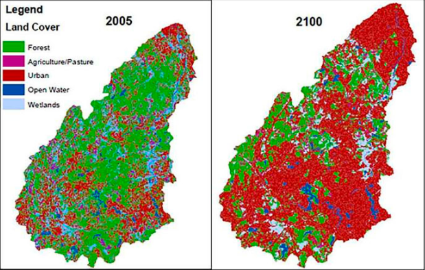
Randhir and his graduate student, first author Ammara Talib, focused on the Sudbury-Assabet and Concord watershed in eastern Massachusetts, an area that includes both rural and Boston suburbs, to make the links between land use and hydrological effects visible and to project these effects into the future.
The researchers fed historical data documenting shifting land use into a model that forecasted patterns for the years 2035, 2065, and 2100. The outputs of the land-use model were then entered into a hydrological model known as the Hydrological Simulation Program-FORTRAN.
They discovered that by 2100, the total wooded area will be reduced by 51%, while impermeable areas (roads and parking lots) will grow by 75%. These improvements will boost yearly stream flow by 3% while increasing runoff by 69%.
All of this increased runoff will result in 54% more topsoil and other solids in the water, as well as 12% and 13% higher phosphorus and nitrogen contents, respectively.
But none of this need happen.
“We can plan for the future on the watershed scale,” says Randhir, by urban planning that implements best practices for sustainable and site-specific land-use measures. These can include creating rain gardens, using permeable pavement in large parking lots and employing vegetated swales to slow the runoff.
“The watershed is a signature of the health of the landscape,” says Randhir. “The quality of life in any particular landscape depends on how the watershed is functioning.”
Source:University of Massachusetts Amherst
