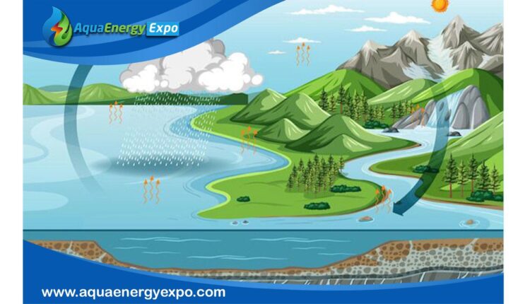
A runoff model, or rainfall-runoff model, describes how rainfall is converted into runoff in a drainage basin (catchment area or watershed). More precisely, it produces a surface runoff hydrograph in response to a rainfall event, represented by an input as a hyetograph.

What is a rainfall-runoff model?
* A rainfall-runoff model is a tool used to simulate the conversion of rainfall into river flow within a watershed.
* It takes rainfall data (often represented as a hyetograph) as input and produces a hydrograph (a graph of flow rate over time) at the outlet of the drainage basin.
* These models are crucial for understanding and managing water resources, predicting floods, and assessing the impact of land-use changes on river flow.
Examples of Rainfall-Runoff Models:
A rainfall-runoff model simulates how rainfall is transformed into river flow within a drainage basin. A common example is the Precipitation-Runoff Modeling System (PRMS), which models various hydrologic processes like evaporation, transpiration, and runoff based on climate data and land use. Other examples include the Probability-Distributed Model (PDM) and the HEC-HMS model, which are used for flood prediction and water resource management.
1-Precipitation-Runoff Modeling System (PRMS).
2-Probability-Distributed Model (PDM).
3-HEC-HMS Model:
* A widely used hydrological modeling system developed by the U.S. Army Corps of Engineers.
* Capable of simulating both short-term and long-term hydrological events.
* Used for flood forecasting, water resource management, and assessing the impact of land-use changes.
Rainfall-runoff modeling based on the HEC-HMS model:
1-Using the Hydrologic Modeling System (HEC-HMS):
The Hydrologic Modeling System (HEC-HMS) was used in this study to simulate precipitation-runoff processes accurately in different types of watersheds. Based on this, a rainfall-runoff model was planned to study specific flood characteristics, evaluate some prediction models, and issue assumptions about their feasibility, which could be useful in establishing flood warning systems.
2-Using the HEC-GeoHMS Tool and Statistical Evaluation Criteria:
The study used the HEC-GeoHMS terrain processing tool, incorporating digital elevation data to build a hydrological model. Statistical indicators used to evaluate runoff mechanisms, specifically regression, coefficient of determination, correlation coefficient, index of agreement, and root mean squared error, showed a strong relationship between simulated and recorded flow for the watershed. The leakage model was evaluated using other statistical criteria, including deviation of runoff volumes, Nash-Sutcliffe efficiency, and Kling-Gupta efficiency. These criteria confirmed that the simulated data were very close to the observed data, indicating effective correlation, and were considered reliable indicators of model quality, ensuring its reliability and effectiveness.
3-Floods as Global Natural Disasters:
Floods are typically responsible for about one-third of global disasters. Unfortunately, these extraordinary phenomena are spreading rapidly, and the frequency and intensity of damages are expected to increase in the future. Floods are the predominant form of natural disasters, resulting from the inundation of usually dry land due to increased water. In tropical regions, floods often result from storms caused by tropical cyclones or tsunamis along the coast. In contrast, in temperate regions, floods commonly begin due to heavy rainfall or rapid snowmelt. Floods can lead to widespread destruction, causing fatalities and damage to private property and vital public health facilities. The occurrence and intensity of floods are increasing, and these trends are expected to worsen due to climate change.
4-Importance of Understanding Runoff in Planning:
Adequate understanding of watershed runoff is crucial for planning and designing water resources and related projects. A runoff simulation model is a hydrological model that analyzes a watershed’s response to rainfall and predicts floods. It is used to enhance water resource management and implement preventive measures against floods in specific hydrographic basins. The Hydrologic Modeling System (HEC-HMS) is a hydrological model that has been used effectively with decisive results. This model has the ability to replicate floods in both immediate and extended scenarios. The timing of runoff can sometimes influence flood effects. As a result, a certain amount of rainfall can cause significant flooding in some areas of the watershed while causing modest flooding in others.
5-Flood Modeling Using HEC-HMS and GIS:
The process of flood modeling can be efficiently conducted using HEC-HMS and GIS. The results of this modeling help in making informed decisions and implementing preventive measures to mitigate the negative effects of floods. ArcGIS uses the HEC-GeoHMS tool as a preliminary tool for hydrological models. The outputs produced by HEC-GeoHMS, such as the network, watershed boundaries, sub-basin boundaries, and watershed and sub-basin centroids, are then imported into HEC-HMS for simulation. HEC-HMS and GIS technologies have undergone extensive testing and have been actively used worldwide for flood modeling purposes for many years. The demand for the modeling system is also driven by the need for effective planning and management of hydrographic basins, enabling accurate decisions on timely flood warnings and the identification of flood risk areas.
6-Impact of Climate Change and Human Intervention:
Climate change, extreme weather events, deforestation, and human intervention negatively impact the environment and the socio-economic conditions of contemporary society. These factors have intensified catastrophic events, leading to fatalities and significant material destruction. Floods are a major global issue, resulting in negative economic consequences. As a result, the interest of scientists and society in this field is currently high. Significant focus has been placed on evaluating and mitigating flood impacts worldwide.

Case study
The objective of this research and hydrological modeling was to quantitatively analyze surface flows in the Gelurt watershed, located in the southern region of Romania, with the aim of generating simulation results. These results can then be employed with various software applications to analyze water availability, terrain drainage, flow forecasting, future climate impacts, reservoir spillway design, flood mitigation, floodplain regulation, and system operation.
To validate the precision of the prediction models for the match between simulated flows and real flows, it was proposed to utilize multiple statistical indicators. Hence, the validation of the models was performed using regression, the coefficient of determination, the Pearson correlation coefficient, and the root mean squared error. In addition, the index of agreement, as stated by Willmott (1981), was computed, as well as other relevant indicators, as an established measure for evaluating the precision of the model’s predictions. Consequently, the objectives of this study were to evaluate the reliability of the HEC-HMS hydrological modeling system in estimating and simulating the rainfall-runoff process in a certain area of Romania associated with excessive rainfall. Using statistical indicators, we also examined the reliability of the model developed for the Gilort watershed.
Conclusion
Watersheds are critical elements for hydrological regulation and the sustainable use of natural resources within this system. The main factors determining drainage networks are geological structure, morphological composition, terrain, and climatic elements. Morphometric studies are valuable tools for planners to enhance the effectiveness of urbanization, agricultural, and industrial activities within the watershed. Many studies using GIS data processing features in ArcGIS have shown that different drainage networks are applicable and sustainable, depending on the watershed shape, drainage texture, and morphometric parameters of the terrain. Remote sensing is a useful technique for quickly obtaining data on the Earth’s surface, including digital elevation models (DEM) and land use and land cover information.
To explore the latest innovations in water and energy technologies and discover a wide range of products and solutions from around the world, you can visit the virtual exhibition AQUA ENERGY EXPO, which features leading companies in water treatment, desalination, and sustainable energy, through the following link: https://aquaenergyexpo.com/
Reference
1- A Study on Estimation of Rainfall-Runoff Simulation Accuracy
2- Rainfall-runoff modeling based on HEC-HMS model: a case study in an area with increased groundwater discharge potential
https://www.frontiersin.org/journals/water/articles/10.3389/frwa.2024.1474990/full
