The Yangtze River, the longest river in Asia, stretches approximately 6,380 kilometers (3,915 miles) and is a vital artery for millions of people. This magnificent river is not only significant for its length but also for its deep cultural, historical, and ecological importance across the continent of Asia.

Understanding the Yangtze River
Known as Changjiang in China, which translates to “Long River,” the Yangtze is the third longest river globally, following the Amazon and the Nile. It begins on the Tibetan Plateau and flows eastward into the East China Sea. The river’s name, “Yangtze,” originated from a section near its mouth, but it has come to represent the entire waterway. In its upper reaches, it is referred to as the Jinsha River, or “Golden Sand River,” as it navigates through stunning gorges adjacent to the Mekong and Salween rivers.

Geographical Features
1.Upper Course
The Yangtze’s upper course flows across the Tibetan Plateau, descending through deep valleys and emerging onto the Yunnan-Guizhou Plateau. Its source, the Ulan Moron River, is fed by glacial melt from the Tanggula Mountains. This section of the river features a diverse landscape with lakes and reservoirs, and it experiences significant elevation changes, dropping over 5,200 meters (17,000 feet) within its first 2,600 kilometers (1,600 miles).
2.Middle Course
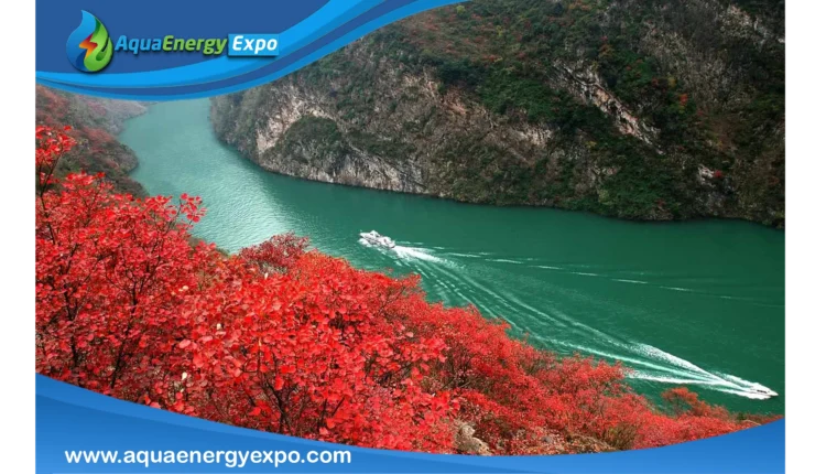
The river’s middle course spans about 1,010 kilometers (630 miles) between Yibin in Sichuan and Yichang in Hubei. This region enjoys a temperate climate, characterized by hot summers and mild winters. The Yangtze flows through the famous Three Gorges, a breathtaking area with steep limestone cliffs that rise dramatically from the water. The completion of the Three Gorges Dam in 2006 significantly altered the landscape, but the gorges remain a stunning natural feature.
3.Lower Course
As the Yangtze approaches its lower course, it enters the lowland plains of east-central China, where it becomes wider and slower. This region, with a temperate climate, is crucial for agriculture, particularly rice production. Major tributaries like the Yuan, Xiang, and Han rivers join the Yangtze here, contributing to its flow. The river widens significantly, reaching up to 800 meters (2,600 feet) in places, and flows through the bustling metropolis of Wuhan, an essential industrial and transport hub.

The Yangtze Delta
The Yangtze delta is a complex network of channels, lakes, and marshes. It features significant cities such as Wuxi, Suzhou, and Shanghai. The delta area is prone to flooding, especially during monsoon seasons. The river divides into two main branches before emptying into the East China Sea, creating a rich ecosystem and fertile land.

Cultural and Economic Significance
The Yangtze River is not just a natural wonder; it is deeply woven into the fabric of Chinese culture and economy. It serves as a vital transportation route, facilitating trade and commerce. The river basin supports nearly one-third of China’s population and is a significant agricultural region, contributing to the country’s food security.
Geology and Hydrology of the Yangtze River
1.Geological Features
The Yangtze River originates in the Tibetan Plateau, where ongoing tectonic activity results from the collision of the Indian and Eurasian plates. The bedrock consists of a mix of marine sedimentary, igneous, and metamorphic rocks. In the intermontane basins, Cenozoic sediments—less than 65 million years old—overlie this bedrock. The river flows down from the Tibetan Plateau through eroded mountain plateaus made of Paleozoic and Mesozoic rocks, dating back about 150 to 350 million years. In its lower reaches, the Yangtze traverses Cenozoic deposits, shaped by sedimentation as it has moved across the basin.
2.Hydrological Dynamics
The Yangtze basin receives an average annual rainfall of around 1,100 mm (43 inches), primarily from monsoon winds, with snow precipitation in mountainous areas. Flooding typically begins in March or April, peaking in August, and can lead to significant water level fluctuations—averaging about 20 meters (65 feet) annually. The Three Gorges Dam mitigates some of these variations, while tidal influences are prominent in the delta, where daily tidal ranges can reach 4.5 meters (15 feet).
The river carries an immense volume of water, with upstream flows exceeding 1,980 cubic meters (70,000 cubic feet) per second. This volume increases significantly after tributaries like the Yalong River join. Before the Three Gorges Dam was completed, the Yangtze’s flow at its mouth reached approximately 31,100 cubic meters (1,100,000 cubic feet) per second, ranking it among the highest in the world.
Environmental Impact
The Yangtze’s sediment load is substantial, with annual estimates of 478 million tons. However, flooding poses risks, particularly when silt deposits raise the riverbed, leading to increased flood potential. Human activities, including pollution and land reclamation, have accelerated environmental degradation in the basin, raising concerns for local ecosystems and communities.

Conclusion
The Yangtze River, as the longest river in Asia, is a symbol of natural beauty and cultural heritage. Its vast length and the diverse ecosystems it supports highlight its significance in the lives of millions. Understanding the Yangtze is essential to appreciating its role in shaping the history and future of China and Asia as a whole.
Reference
1.11+ fascinating facts about the longest river in Asia
https://vinpearl.com/en/longest-river-in-asia
2.Yangtze River
https://www.britannica.com/place/Yangtze-River
