The longest river of Spain, the Ebro(987km), is the largest in the Iberian Peninsula, primarily because of the significant contributions from its tributaries.

Tributaries and Geography of the Ebro River Basin
The left bank of the Pyrenees features the longest tributaries with the highest flow into the Ebro River. Before reaching the Aragonese border, the Ebro receives several tributaries on its left bank, including Híjar, Nela, Jerea, Omecillo, Bayas, Zadorra, Ega, and Aragón-Arga. Upon entering Aragon, it also incorporates the Arba de Luesia, Gállego, and the Segre-Cinca complex along with its significant tributaries.
Tributaries of the Ebro River on the Right Bank
Leading up to the Aragonese border, the Ebro gathers tributaries on its right bank such as Oca, Tirón, Najerilla, Iregua, Leza, Cidacos, Alhama, and Queiles. Once in Aragon, it continues to receive the rivers Huecha, Jalón (along with an extensive network of tributaries), Huerva, Aguas Vivas, Martín, Guadalope, and Matarraña on its right bank.
Main Rivers and Reservoirs of the Ebro Basin
The Ebro River basin spans nine autonomous communities, eighteen provinces, and approximately 1,700 municipalities, ultimately flowing into the Mediterranean Sea. It also encompasses regions in Andorra and the French Cerdanya or Haute Cerdagne.

Climate of the Ebro Basin
Downstream from Cantabria, the climate in the Ebro basin is influenced by both Mediterranean and Atlantic conditions, becoming increasingly continental due to the surrounding mountains that isolate it from sea air masses. This results in distinct seasonal contrasts between summer and winter, characterized by a relatively dry climate. Summers in the Ebro Valley often resemble those of a semiarid region, with some years experiencing more storms and showers, while others face significant drought, particularly in areas without advanced irrigation.
The valley’s floodplains receive annual rainfall ranging from 300 to 600 mm (12–24 in), peaking in fall and spring, and are typically covered with chaparral vegetation. Summers are hot, with temperatures often exceeding 35 °C (95 °F) and occasionally surpassing 40 °C (104 °F). Winters can be quite cold, with temperatures frequently dropping below 0 °C (32 °F). In certain regions, vegetation relies heavily on moisture from condensation fog. The climate is classified as continental Mediterranean, featuring extreme temperature variations, frequent ground frosts on clear nights, and occasional snowfall.

Flow Volume of the Ebro River
As the Ebro River flows through Aragon, the valley widens, causing its flow to slow while water volume increases. Larger tributaries from the central Pyrenees and the Iberian System contribute significant amounts of water, particularly during spring when snowmelt occurs in the mountains. This seasonal thaw enhances the river’s flow, resulting in a more substantial water volume as it progresses downstream.

Diverse Biomes and Landscape Features of the Ebro Valley
The Mediterranean climate zones host a variety of biomes, including Mediterranean forests, woodlands, and scrub. The hinterlands are particularly notable for their extensive sclerophyll shrublands, known as maquis or garrigues. Dominant species include Quercus coccifera in drier regions and Quercus ilex, often forming monospecific communities or mixed forests with Pinus, Mediterranean buckthorns, Myrtus, Chamaerops humilis, junipers, Pistacia, Rosmarinus, and Thymus.
As the hinterland climate becomes more continental and arid, it transitions from extreme temperatures and slow-growing dwarf juniper species to barren desert steppes, such as the “llanos de Belchite” or “Calanda desert.”
Mountain vegetation predominantly consists of drought-resistant coniferous forests, while hardier oak species (Quercus) thrive in the wetter highlands. In endorheic lagoons and their tributaries, halophiles flourish, including endemic bryophytes and various families like Chenopodiaceae and Asteraceae, reflecting the valley’s marine origins.
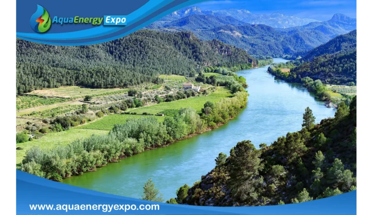
Upon entering Catalonia, the valley narrows, and the river is flanked by mountain ranges, creating wide bends. Three significant dams—Mequinenza (1955), Riba-roja (1955), and Flix (1948)—have been constructed in this area. In its final stretch, the river meanders south through stunning gorges, bordered by the calcareous cliffs of the Serra de Cardó, before bending eastward near Tortosa and flowing into the Mediterranean Delta close to Amposta in Tarragona.
Reference
2.Ebro https://en.m.wikipedia.org/wiki/Ebro
2.FACT SHEET: Ebro River Basin
https://water.jrc.ec.europa.eu/pdf/ebro-fs.pdf
